SKYWARN® Trained Amateur Radio Support Team Providing Ground Truth Under The Radar
Boulder SKYWARN® & CWA Information
Office & CWA Overview
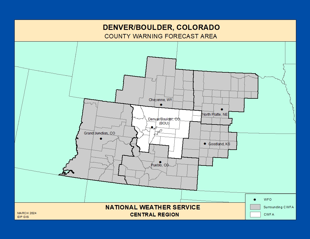
The National Weather Service Weather Forecast Office (WFO) in Denver/Boulder, Colorado
provides forecasts, warnings, and decision‑support services for much of north‑central
and northeast Colorado, including the foothills, Front Range urban corridor, and
adjacent high plains east of the Continental Divide.
This County Warning Area (CWA) spans complex terrain from the Rocky Mountain foothills
into the eastern plains, with a wide range of hazards: severe thunderstorms, large hail,
tornadoes, flash flooding, downslope wind events, dangerous winter storms, and periods
of elevated to critical fire weather.
Weather observations in the Front Range region date back well over a century, with
cooperative observers, river‑gauge networks, and early Weather Bureau operations
supporting agriculture, transportation, and water‑resource management in the growing
corridor between Denver and Colorado Springs.
The modern Denver/Boulder forecast office and its WSR‑88D radar provide coverage from
the high foothills across the metro area and onto the eastern plains, supporting
aviation, hydrology, fire weather, and public forecast services for one of the most
densely populated and rapidly changing regions in Colorado.
Today, WFO Denver/Boulder issues forecasts and warnings for the Front Range urban
corridor, I‑25, I‑70 mountain passes, small‑town communities, ranching interests,
and major recreation and transportation hubs across the CWA.
Notable Historic Weather Events in the NWS Denver/Boulder CWA
Severe Thunderstorms & Tornadoes
During the warm season, organized storm systems and isolated supercells can produce
large hail, damaging winds, and tornadoes across the Front Range foothills, urban
corridors, and the plains east of Denver.
Reports of hail size, wind damage, and rotation are critical for timely warnings and
for communicating specific risks to outdoor events, schools, and transportation
networks.
Flash Flooding & Urban Flood Events
Slow‑moving thunderstorms or cold‑front lift can produce intense rainfall over
steep foothills, small drainages, and urban catchments, leading to flash flooding
and rapid creek rises across the CWA.
Roads, underpasses, and low‑lying areas can fill quickly, threatening motorists,
campers, and residents in burn‑scar regions where soils are less able to absorb water.
Downslope Wind Events & High Winds
Favorable pressure and jet‑stream patterns can trigger strong downslope winds along
the Front Range, producing gusts well over 60 mph and creating hazardous conditions
for travel, aviation, and outdoor structures.
These events can coincide with dry conditions, increasing the risk of wind‑driven
wildfire spread and power‑outage cascades.
Winter Storms, Blowing Snow & Extreme Cold
Major winter storms bring heavy snow, blinding blowing snow, and whiteout conditions
to the foothills and passes, while strong Arctic outbreaks can drive extreme wind
chills across the plains and urban corridors.
Accumulating snow and drifting can shut down I‑70 mountain routes, secondary highways,
and local roads, impacting commuters, emergency services, and critical infrastructure.
Fires in Northern Colorado
Dry, windy conditions helped accelerate the spread of the Cameron Peak fire to recording breaking acreage.
Historic firestorm illustrates some of the ways NOAA responds when disaster strikes
Coordination between WFO Denver/Boulder, land management agencies, and SKYWARN®
spotters helps track new fire starts, rapid‑spread events, and smoke that can reduce
visibility and air quality across the region.
East Troublesome Fire
Thousands of acres burned in less than a month with the only hope to stop the fire being a dramatic change in the weather.
Explore additional historic weather information, hydrologic resources, and forecast
discussions for north‑central and northeast Colorado via the
NWS Denver/Boulder office website
.
Denver/Boulder SKYWARN® & Spotter Program
The Denver/Boulder WFO maintains a SKYWARN® spotter network across the
Front Range and adjacent plains, relying on trained volunteers to report hazardous
weather in areas where radar coverage and surface observations can be limited.
Spotters include amateur radio operators, emergency managers, law enforcement and
fire personnel, transportation and utility workers, school and event staff, and
engaged community members who provide critical ground truth during severe weather
and winter storm events.
Denver/Boulder SKYWARN® Program
Overview of SKYWARN® in the Denver/Boulder CWA, including who can become a
spotter, training expectations, and reporting basics.
Amateur radio–based severe weather support for NWS offices across the central Rockies
and High Plains, including coordination with Denver/Boulder during regional events. [web:8]
Use these topics to guide SKYWARN® training tailored to the Front Range,
urban corridors, and high‑plains environments in the Denver/Boulder CWA.
Convective storms – Supercells, bow‑echoes, and pulse storms
producing large hail, damaging winds, and occasional tornadoes in urban and
rural areas.
Flash flooding – Rapid rises in urban channels, street
drainage systems, and small streams, especially following heavy thunderstorms
or rapid snowmelt events.
Winter weather – Heavy snow, ice storms, and strong winds
affecting the foothills, I‑70 corridor, and adjacent plains, including
snow levels and drift impacts.
Fire weather – Dry thunderstorms, gusty outflows, very low
humidity, and shifting winds that can rapidly spread grass and timber fires.
Local live and virtual SKYWARN® training sessions are announced on the
Denver/Boulder website and through partner agencies.
Significant Weather Event Reporting Criteria
National Weather Service – Denver/Boulder Forecast Office