Pueblo SKYWARN® & CWA Information
Office & CWA Overview
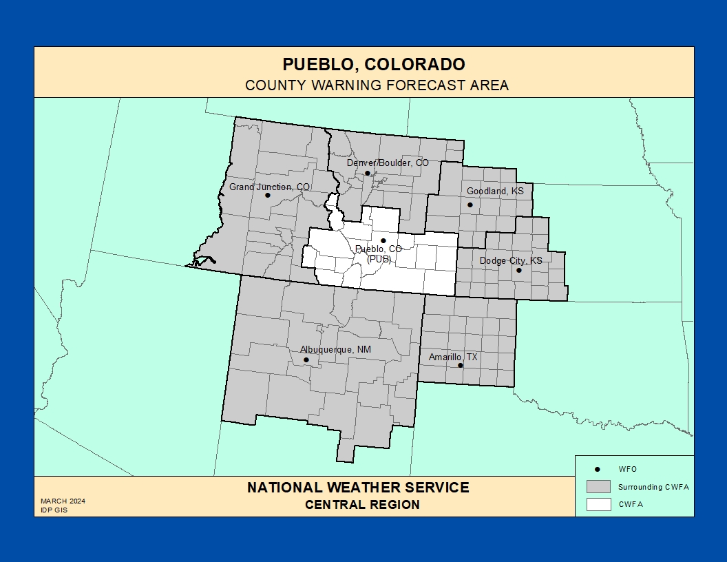
The National Weather Service Weather Forecast Office (WFO) in Pueblo, Colorado provides forecasts, warnings, and decision support services for 21 counties across south-central and southeast Colorado, including the Upper Arkansas River Valley, the I‑25 corridor from Monument Hill south to Trinidad, the eastern plains, and portions of the San Luis Valley.
This County Warning and Forecast Area (CWFA) experiences a broad range of hazardous weather: high‑end snowstorms and blizzards, major flash flooding, dangerous downslope and gap winds, severe thunderstorms and tornadoes on the plains, and critical fire weather driven by strong winds and very low humidity.
https://www.weather.gov/pimar/CWAbyWFO
Click here for the Pueblo Area Photo Gallery!Historic Weather & Office Background
Modern National Weather Service operations in Pueblo trace back to earlier Weather Bureau and cooperative observing programs that documented the region’s notorious floods, blizzards, and dust storms across southern Colorado.
As part of the NWS modernization in the 1990s, the office relocated to the Pueblo Memorial Airport Industrial Park, with ASOS observations at the airport and a WSR‑88D Doppler radar northeast of town providing coverage across the mountains and plains of the CWFA.
Today, WFO Pueblo serves as a hub for forecasts, severe weather warnings, fire weather support, and decision support services for emergency management across south‑central and southeast Colorado.
Notable Historic Weather Events in the NWS Pueblo CWA
Great Pueblo Flood – June 3, 1921
On the evening of June 3, 1921, torrential rain over the Arkansas River and Fountain Creek basins produced a catastrophic flood that swept through downtown Pueblo, destroying large portions of the city and killing hundreds of people.
Estimates suggest 6 inches or more of rain fell between June 3 and June 5 in the watershed above Pueblo, with a wall of water inundating rail yards, businesses, and homes near the confluence of Fountain Creek and the Arkansas River.
Southern Colorado Flash Floods – Canon City & Royal Gorge Episodes
Numerous flash flood events in canyons such as the Royal Gorge and along the Arkansas River and its tributaries have impacted communities within the Pueblo CWA, producing rapid rises, debris flows, and road washouts.
These events highlight the vulnerability of canyon corridors, burn scars, and steep terrain to intense summertime thunderstorms common in the region.
High‑Impact Winter Storms & Blizzards
Major winter storms periodically bring heavy snow, blowing and drifting, and blizzard conditions to the Palmer Divide, Raton Mesa, Wet and Sangre de Cristo Mountains, and the eastern plains within the Pueblo CWFA.
Prolonged road closures along I‑25 and U.S. 50, along with power outages and livestock losses on the plains, are recurring impacts during the strongest winter systems.
Severe Thunderstorms & Tornadoes on the Plains
From late spring through summer, severe thunderstorms produce large hail, damaging winds, and occasional tornadoes across the Arkansas River Valley, lower Arkansas Valley, and adjacent plains of southeast Colorado.
Long‑lived supercells can track for many miles, impacting rural communities, agriculture, and transportation corridors east of Pueblo.
Critical Fire Weather & Wind Events
Strong downslope winds, low humidity, and dry fuels frequently combine to create critical fire weather conditions over the plains, mesas, and mountain slopes in the Pueblo CWA.
Rapid fire spread, smoke‑reduced visibility, and erratic wind shifts are key concerns for wildfires in south‑central and southeast Colorado.
Explore additional historic weather information and event summaries for southern
Colorado on the
NWS Pueblo office website
.
Scroll through the story of the Great Pueblo Flood that devastated an the town and stifled progress for many years after.
Deuling Fires
Scroll through the story of the Deuling Fires. Two fires and their impacts on El Paso County in the span of a single year. Two of the most destructive wildfires in Colorado history started almost exactly a year apart and only a couple of miles away from each other.
Pueblo SKYWARN® & Spotter Program
The Pueblo WFO maintains a SKYWARN® storm spotter network across south‑central and southeast Colorado, including trained volunteers from along the I‑25 corridor, the Wet and San Luis Valleys, and the eastern plains.
Spotters include amateur radio operators, emergency management, law enforcement, fire and EMS, transportation and utility crews, and engaged citizens who provide real‑time reports during severe weather and high‑impact events.
Official Pueblo Spotter Page
Training schedules, reporting methods, and SKYWARN® program details for southern Colorado.
Spotter Talks & Training
In‑person and virtual spotter talks offered by NWS Pueblo each year, covering severe storms, flooding, winter weather, and safety.
Colorado Severe Weather Network
Amateur radio–based severe weather support for NWS offices across the central Rockies and High Plains, including coordination with Pueblo during regional events.
Training & Reference for Spotters
Use these resources to build and refresh SKYWARN® skills tailored to the mountains, valleys, plains, and fire‑prone landscapes of the Pueblo CWA.
- Convective storms – Supercells, landspout and tornado potential on the plains, hail cores, and outflow boundaries along the Arkansas River Valley.
- Winter weather – Heavy snow in the mountains and along the Palmer Divide, ground blizzards on the open plains, and upslope snow events along the I‑25 corridor.
- Hydrology – Flash flooding in canyons, arroyos, and burn scars, plus snowmelt‑driven rises on the Arkansas River and its tributaries.
- Fire weather – Strong winds, very low humidity, rapid fire spread, and smoke impacts to visibility and health.
Additional online modules, recorded talks, and case studies will be linked here as more Pueblo‑specific training material becomes available.
Significant Weather Event Reporting Criteria
National Weather Service – Pueblo Forecast Office
How to Report
- Online: NWS Storm Report Form
- Spotter Hotline: Check local NWS Pueblo spotter materials for the latest phone contact.
- Email: Use the contact options provided on the Pueblo spotter page or local EM channels.
- Social Media: @NWSPueblo (X / Facebook) when appropriate, following NWS guidance.
Flooding, Flash Flooding & Heavy Rain
- Rapid rises in streams, creeks, arroyos, or low‑lying areas
- Water flowing faster or higher than normal
- Water threatening or covering roads, homes, or infrastructure
- One inch or more of rain in a short period
- Debris flows or mudslides, especially near burn scars
Winter Weather
- Measured snowfall amounts and time period
- Snow depth measurements and drift depths
- Blowing snow, whiteout, or blizzard conditions
- Freezing rain, ice accumulation, or significant glaze
Fire Weather
- New wildfire starts or rapid fire growth
- Smoke reducing visibility below 2 miles
- Strong, erratic winds affecting fire behavior
Convective / Thunderstorm Weather
- Tornado / Landspout: Rotating column of air touching the ground
- Funnel Cloud: Rotating, not touching the ground
- Wall Cloud: Persistent lowering from storm base
- Hail: Any size (include measurements and comparison objects)
- Wind: Damage, downed trees or power lines, or ~50 mph or greater
High Wind & Dust
- Widespread blowing dust reducing visibility
- Wind‑blown damage to structures, signs, or vehicles
- Transport trucks or high‑profile vehicles blown over or off the road
Pueblo SKYWARN® Spotter Training
Upcoming and recorded spotter training opportunities for southern Colorado are listed on the Pueblo spotter and spotter talks pages.
Key Links for the Pueblo CWA
Pueblo & Southern Colorado History
Additional historical resources about the 1921 Pueblo Flood, Arkansas River basin, and Colorado water history are available from local and state archives and university collections.