Salt Lake City SKYWARN® & CWA Information
Office & CWA Overview
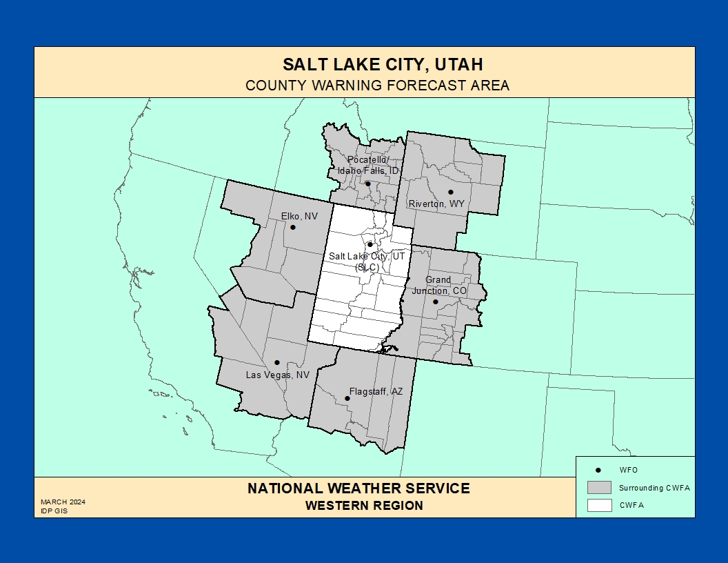
The National Weather Service Weather Forecast Office (WFO) in Salt Lake City, Utah provides forecasts, warnings, and decision support services for much of Utah and southwest Wyoming, including the Wasatch Front, the Salt Lake Valley, and adjacent mountain and desert regions.
This County Warning Area (CWA) experiences a wide range of hazardous weather: winter storms and blizzards, strong downslope and canyon winds, flash flooding from monsoon thunderstorms, lake‑effect snow off the Great Salt Lake, and the occasional severe thunderstorm or tornado.
https://www.weather.gov/pimar/CWAbyWFO
Click here for the Salt Lake City Area Photo Gallery!
Historic Weather & Office Background
Formal weather observations in Salt Lake City date back to the mid‑1800s, with early records kept by volunteer observers before the Signal Service and later the Weather Bureau established official offices downtown in the late 19th century.
Over time, Weather Bureau and then National Weather Service offices in Salt Lake City moved among several prominent downtown buildings and eventually to modern facilities near the airport, supporting aviation, public, hydrologic, and fire weather operations across the region.
Today Salt Lake City also hosts a regional National Weather Service headquarters, reflecting its central role in Western Region forecasting and support services.
Notable Historic Weather Events in the NWS Salt Lake City CWA
Salt Lake City F2 Tornado – August 11, 1999
On August 11, 1999, an F2 tornado touched down in the metropolitan area of Salt Lake City, Utah. It remained on the ground for about 10 minutes, killed one person, injured more than 80 people, and caused more than $170 million in damage, making it the most destructive tornado in Utah’s history.
The tornado track was roughly 4 miles long and about 100–200 yards wide, passing near what is now the Delta Center, north of Temple Square, through Memory Grove, and into the Avenues neighborhood.
Record Snowmelt Flooding and Thistle Landslide – Spring–Summer 1983
During spring and early summer 1983, Utah experienced some of the most severe and extensive snowmelt flooding in its recorded history, heavily impacting communities along the Wasatch Front, including parts of the Salt Lake City CWA.
A massive landslide near Thistle dammed the Spanish Fork River, inundated the town, destroyed sections of U.S. Highway 6 and the Denver and Rio Grande Railroad, and contributed to widespread high flows and flooding on creeks in the Salt Lake Valley.
“Once-in-100-Year” Snowstorm – January 6–11, 1993
A prolonged winter storm in early January 1993 produced nearly continuous heavy snow over about six days in Salt Lake County, described as a “once‑in‑100‑year” event.
Salt Lake City International Airport reported a storm total of about 23 inches of snow, with around 3 feet measured in parts of eastern Salt Lake Valley, leading to a state of emergency declaration and activation of the Utah National Guard to assist with snow removal.
Severe Canyon Winds along the Wasatch Front – January 1984 (Representative Episode)
A severe canyon wind episode along the Wasatch Front produced widespread wind gusts of 60–80 mph, with a peak gust over 100 mph reported near the Hill Air Force Base / Layton area.
The event damaged or destroyed dozens of major transmission towers, overturned railcars, and caused extensive structural and glass damage in communities such as Ogden, illustrating the extreme downslope wind potential in the Salt Lake City CWA.
Historic Daily Rainfall – May 3, 1901 and Modern Benchmark Event
On May 3, 1901, Salt Lake City recorded 2.64 inches of rain in 24 hours, which remains one of the city’s highest single‑day rainfall totals on record.
More than a century later, a recent storm produced 2.43 inches of rain in 24 hours, the wettest day in over 120 years, causing basement flooding and stressing local drainage systems in Salt Lake City neighborhoods.
Unseasonable Cold and Snow – Late June to Early July 1968
An unusually cold late‑June pattern brought windy conditions and snow to higher elevations in and around Utah, with campers in nearby Yellowstone shivering around campfires while Salt Lake City recorded a record low of 40°F on July 1.
The event stands out as an example of how late‑season cold outbreaks can briefly disrupt typical summer weather patterns across the broader Salt Lake City forecast area.
Scroll through the story of a rare but powerful tornado that touched down in downtown Salt Lake City on August 11, 1999.
SLC SKYWARN® & Spotter Program
The Salt Lake City WFO maintains a volunteer weather spotter network with hundreds of trained observers across Utah and southwest Wyoming who report hazardous weather in real time.
Spotters include amateur radio operators, public safety personnel, emergency managers, transportation and utility employees, and weather‑aware citizens who help provide critical ground truth during high‑impact events.
Official SLC Spotter Page
Training dates, online modules, reporting guidance, and contact information for the Salt Lake City spotter program.
National SKYWARN® Program
National overview of SKYWARN®, including how spotter reports are used, basic training, and links to additional educational materials.
Colorado Severe Weather Network
Amateur radio–based severe weather support for NWS offices across the central Rockies and High Plains, including coordination with SLC during regional events. We are proud to serve all of our NWS and Amateur Radio partners.
Training & Reference for Spotters
Use these resources to build and refresh SKYWARN® skills specific to the high terrain, cold‑season, and monsoon‑driven hazards of the SLC CWA.
- Convective storms – Supercells, pulse storms, outflow boundaries, and terrain‑driven storm behavior along the Wasatch and adjacent ranges.
- Winter weather – Orographic snow, lake‑effect bands, mountain passes, and differentiating heavy snow from mixed‑precipitation events.
- Hydrology – Flash flooding in canyons, debris flows from burn scars, and snowmelt‑driven river rises.
- Wind events – Downslope and gap winds, canyon wind events, and synoptic‑scale high wind warnings.
Many offices now use ArcGIS StoryMaps and online modules to deliver interactive SKYWARN® content; links will be added here as SLC‑specific StoryMaps become available.
Significant Weather Event Reporting Criteria
National Weather Service – Salt Lake City Forecast Office
How to Report
- Online: NWS Storm Report Form
- Spotter Hotline: 800-882-1432 (ext. 1)
- Email: utah.spotter@noaa.gov
- Social Media: @NWSSaltLakeCity (X / Facebook)
Flooding, Flash Flooding & Heavy Rain
- Rapid rises in streams, washes, or low-lying areas
- Water flowing faster or higher than normal
- Water threatening roads, homes, or infrastructure
- One inch or more of rain in a short period
- Debris flows or mudslides
Winter Weather
- Measured snowfall amounts and time period
- Snow depth measurements
- Freezing rain or ice accumulation
- Changes in precipitation type
Fire Weather
- New wildfire starts
- Smoke reducing visibility below 2 miles
- Rapid weather changes affecting fire behavior
Convective / Thunderstorm Weather
- Tornado: Rotating column of air touching the ground
- Funnel Cloud: Rotating, not touching the ground
- Wall Cloud: Persistent lowering from storm base
- Hail: Any size (include measurements)
- Wind: Damage, downed trees, or ~50 mph or greater
Marine & Lake Weather
- Strong winds or hazardous waves
- Waterspouts
- Dense fog affecting visibility
SLC SKYWARN® Spotter Training
Key Links for the SLC CWA
Salt Lake City History
Scroll through the history of Salt Lake City