Goodland SKYWARN® & CWA Information
Office & CWA Overview
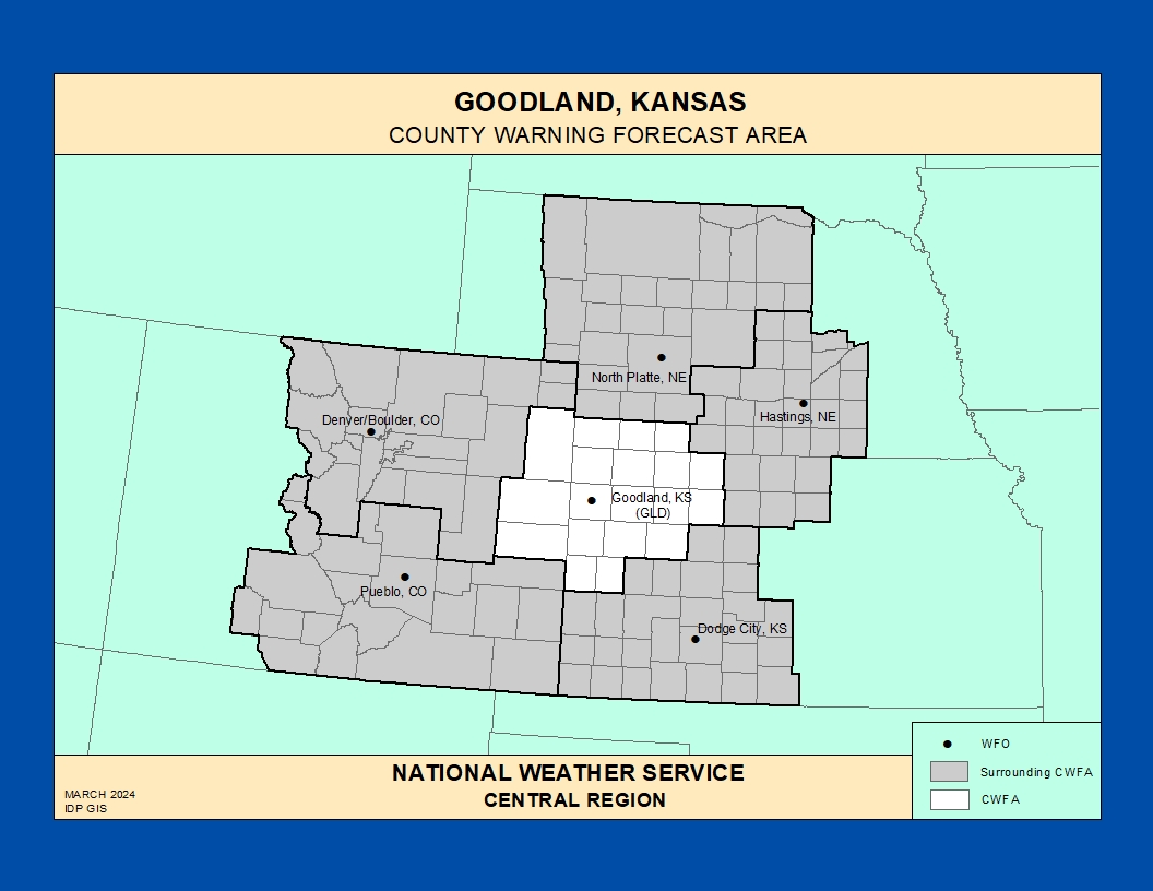
The National Weather Service Weather Forecast Office (WFO) in Goodland, Kansas provides forecasts, warnings, and decision‑support services for the Tri‑State region of northwest Kansas, southwest Nebraska, and far eastern Colorado.
This County Warning Area (CWA) covers 19 counties and more than 21,000 square miles of High Plains, with a sparse population of about 80,000 people and an average density under 4 people per square mile. The CWA experiences a wide range of hazards, including severe thunderstorms, large hail, tornadoes, flash flooding, blizzards, blowing dust, and periods of elevated to critical fire weather.
[https://www.weather.gov/pimar/CWAbyWFO](https://www.weather.gov/pimar/CWAbyWFO)
Click here for the Goodland Area Photo Gallery!Historic Weather & Office Background
Goodland is located on the High Plains of northwest Kansas near the Colorado and Nebraska borders at roughly 3,700 feet above sea level, serving as the county seat of Sherman County. Weather records for Goodland extend back to the late 1800s, documenting over a century of High Plains climate and storm history.
The modern Goodland forecast office supports aviation, fire weather, hydrology, and public forecast services for the region, including terminal forecasts for Goodland, KS and McCook, NE. The office also supports an extensive cooperative observer network and maintains climatological data and event summaries for the Tri‑State area.
Today, WFO Goodland issues forecasts and warnings for farming and ranching interests, rural communities, major highways such as Interstate 70, and smaller regional airports spread across its largely agricultural CWA.
Notable Weather Hazards in the NWS Goodland CWA
Severe Thunderstorms & Tornadoes
The Goodland CWA sits in a corridor favorable for severe thunderstorms and tornadoes, with documented tornadoes across all 19 counties in the Tri‑State area. Supercells and organized convective systems can produce very large hail, damaging winds, and occasional strong tornadoes during the warm season.
Storm spotter reports of hail size, wind damage, rotation, and tornadoes are critical for warning decisions and for communicating specific risks to rural communities, highway traffic, and outdoor activities across the plains.
Flash Flooding & Heavy Rain
Slow‑moving thunderstorms and training bands can produce intense rainfall over small basins, dry creek beds, and low‑water crossings, leading to flash flooding in normally dry areas. Rural roads, culverts, and low‑lying areas can flood quickly, posing risks to motorists, ranch operations, and small communities.
Spotter reports of rapidly rising water, flooded roads, and debris‑laden flows help forecasters assess the severity and are especially valuable where stream gages and other instrumentation are sparse.
High Winds, Blowing Dust & Blizzards
Strong pressure gradients across the High Plains can produce widespread high winds and blowing dust, reducing visibility and creating hazardous travel conditions. In winter, these winds combine with snow to produce ground blizzards, whiteout conditions, and significant drifting across open fields and roadways.
High‑profile vehicles along Interstate 70, U.S. 27, and other regional highways are especially vulnerable to strong crosswinds, while blowing dust and snow can severely impact visibility and close roads.
Winter Storms & Extreme Cold
Winter storms in the Goodland CWA can bring periods of heavy snow, blowing and drifting snow, and dangerous wind chills across the open plains. Prolonged Arctic outbreaks can cause extreme cold, stressing livestock and impacting infrastructure such as water and transportation systems.
Snow and blowing snow can create hazardous travel on rural roads and major highways, complicating emergency response and supply routes across the Tri‑State region.
Fire Weather & Drought
Extended dry periods, low humidity, cured grasses, and strong winds can produce elevated to critical fire weather conditions across the High Plains within the Goodland CWA. Drought can further increase the risk of fast‑moving grass and rangeland fires.
Coordination between WFO Goodland, land management agencies, emergency managers, and SKYWARN® spotters helps track new fire starts, rapid fire growth, and smoke plumes that reduce visibility and affect air quality along key transportation corridors.
Explore additional historic weather information, hydrologic resources, and forecast discussions for the Tri‑State area via the NWS Goodland office website .
Goodland SKYWARN® & Spotter Program
WFO Goodland works with a network of SKYWARN® storm spotters and local partners across northwest Kansas, southwest Nebraska, and eastern Colorado to provide critical ground truth during severe weather and winter storm events.
Spotters include amateur radio operators, emergency managers, law enforcement and fire personnel, public works and utility staff, and engaged community members who report hazardous weather and impacts in areas where radar and surface observation coverage may be limited.
Goodland SKYWARN® Program
Overview of SKYWARN® in the Goodland CWA, including who can become a spotter, training expectations, and reporting basics.
Storm Spotter Training & Schedule
Annual SKYWARN® storm spotter classes, including in‑person and virtual options, are offered each year, typically in late winter and early spring, with registration links posted online.
National SKYWARN® Resources
National training materials, spotter field guides, and safety resources that support SKYWARN® programs across the country, including the High Plains.
Training & Reference for Spotters
Use these topics to guide SKYWARN® training tailored to the High Plains environment of northwest Kansas, southwest Nebraska, and eastern Colorado within the Goodland CWA.
- Convective storms – Supercells, line segments, and pulse storms that can produce large hail, damaging straight‑line winds, and tornadoes across open rangeland and agricultural fields.
- Flash flooding – Rapid rises in small streams, ditches, and low‑water crossings, along with flooded rural roads after slow‑moving thunderstorms or repeated storm tracks.
- Winter weather – Heavy snow, blowing and drifting snow, and dangerous wind chills affecting livestock, rural communities, and major transportation routes such as I‑70.
- Fire weather – Gusty winds, very low humidity, and dry fuels leading to fast‑moving grassfires and rangeland fires that can rapidly change direction with shifting winds.
Next, scroll through the StoryMap to learn about the Christmas Blizzard of 2023. A low pressure system impacted portions of the Central Plains on December 25-26, 2023… beginning Christmas Day.
Local SKYWARN® training opportunities and updates are announced on the Goodland website and through partner emergency management agencies across the Tri‑State region.
Next, scroll through the StoryMap to have an all-inclusive look at Weather safety. Here you will learn about various weather related phenomena.
Significant Weather Event Reporting Criteria
National Weather Service – Goodland Forecast Office
How to Report
- Online: Use the national NWS Storm Report Form when available for your area.
- Phone: Use contact numbers provided during your local SKYWARN® training or listed on the Goodland NWS website and spotter pages.
- Email: Use the email contact listed on the Goodland office or spotter training page to send reports, photos, and follow‑up details.
- Social Media: Tag the Goodland office account on supported platforms when appropriate, following NWS guidance and local instructions.
Flooding, Flash Flooding & Heavy Rain
- Rapid rises in creeks, streams, ditches, or normally dry channels.
- Water flowing faster or higher than normal, especially over low‑water crossings or culverts.
- Water covering or threatening rural roads, farmsteads, homes, or small town streets.
- One inch or more of rain in a short period, or intense bursts that cause quick runoff.
- Debris flows or washouts impacting roads, fields, or infrastructure.
Winter Weather
- Measured snowfall amounts with location and time period.
- Snow depth and drift depths in open country, along fence lines, and across major roads.
- Freezing rain, ice glazing, or reports of slick roads and sidewalks.
- Blowing snow, whiteouts, or closure‑level impacts on highways and rural routes.
Fire Weather
- New wildfire starts or notable flare‑ups in grassland or cropland.
- Smoke reducing visibility below about 2 miles, especially near highways or communities.
- Strong, erratic winds that significantly affect fire behavior or suppression efforts.
Convective / Thunderstorm Weather
- Tornado / Funnel: Any rotating funnel cloud or tornado, with direction and movement when possible.
- Hail: Any size hail, with measurements and comparison objects such as coins or balls.
- Wind: Damage to trees, power lines, outbuildings, or estimated winds around 50 mph or greater.
- Lightning: Frequent cloud‑to‑ground strikes or lightning causing fires, damage, or power outages.
High Wind, Blowing Dust & Reduced Visibility
- Strong winds producing blowing dust and reduced visibility on highways and open roads.
- Wind‑blown damage to structures, trees, irrigation equipment, or vehicles.
- High‑profile vehicles affected along major corridors such as I‑70 and key north‑south routes.